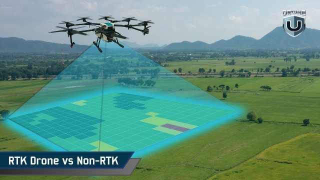
Is an RTK drone an absolute necessity for capturing accurate, professional-grade maps, or are you simply paying a premium for precision that won't actually impact your final deliverables?
Many manufacturers market Real-Time Kinematic (RTK) drones as the ultimate baseline for professional mapping. However, the reality is far more nuanced. Some mapping professionals fly RTK drones but still rely on ground control points (GCPs) to ensure accuracy, while others use standard, non-RTK drones to achieve the exact same project requirements.
The true difference doesn't lie in the label on the drone's box. It comes down to how positional accuracy impacts your operational workflow, your labor costs, and your overall project risk.
In this comprehensive guide, we will break down the real-world differences between RTK and non-RTK drones, comparing accuracy, workflow efficiency, and total cost of ownership. By the end, you will know exactly when RTK is a critical investment and when it just adds unnecessary complexity.
Basic Terminology and Concepts
The drone mapping industry is filled with acronyms like GPS, RTK, and PPK. Misunderstanding these can lead to costly errors in your GIS and mapping workflows. Let's clarify what each term actually means.
Traditional GNSS (Standard GPS)
A standard, non-RTK drone uses traditional GNSS (Global Navigation Satellite System)—the same technology found in your smartphone. In optimal, open-sky conditions, it provides positional accuracy within 1 to 3 meters. While suitable for basic visual mapping, these small positional errors can compound across large sites, causing maps to warp, shift, or misalign with external data.
What Constitutes "High-Accuracy" in Mapping?
High accuracy does not mean absolute perfection; it means positional errors are minimized enough to allow for reliable measurements, seamless overlays, and accurate change detection. For most photogrammetry and GIS applications, this requires centimeter-level precision.
What is an RTK Drone?
An RTK (Real-Time Kinematic) drone receives live correction data while it is in the air. A ground-based reference station (or a regional network) calculates satellite timing errors in real-time and transmits those corrections directly to the drone. This allows the drone to tag each image with a highly precise, centimeter-level location at the exact moment of capture.
What is a Non-RTK Drone?
A non-RTK drone relies solely on its onboard GNSS receiver without live corrections. This doesn't mean it can't be used for professional mapping; it simply means accuracy must be established post-flight. By utilizing strategically placed ground control points (GCPs), a non-RTK drone can achieve GIS-ready results. Without them, absolute accuracy remains at the meter level.
What is PPK (Post-Processed Kinematic)?
PPK is similar to RTK, but the corrections are applied after the flight rather than during it. The drone logs raw satellite data, which is later corrected against a base station’s logs on a computer. It is highly reliable because it doesn't depend on a real-time radio link, and many professionals use PPK as a backup even when flying an RTK drone.
How RTK Works: A Technical Overview
To understand why RTK is valuable, you have to understand where satellite errors come from.
Satellite signals travel vast distances through the Earth's atmosphere, bouncing off terrain and buildings before reaching your drone. These atmospheric and reflective disruptions cause tiny timing errors. A standard GNSS receiver can't correct these in real time, leading to the "drift" often seen in standard drone maps.
An RTK system eliminates this through a three-part architecture:
- The Rover: The drone itself, acting as the moving receiver.
- The Reference Station: A base station on the ground (or a regional network) placed at a known, fixed location to measure satellite deviations.
- The Data Link: The connection (cellular or radio) that sends corrections from the base to the drone.
Because the base station knows its exact location, it can instantly calculate the error in the satellite signal and tell the drone how to correct its coordinates. However, if this live connection drops due to terrain or interference, the drone reverts to standard GNSS accuracy. RTK is a precision tool, but it doesn't fix poor flight planning, motion blur, or bad lighting.
How Non-RTK GNSS Works
Non-RTK drones calculate their position using only satellite timing, without knowing how much the signal is drifting. Processing software will stitch the images together based on visual overlap, creating a map that looks internally consistent (good relative accuracy) but may be shifted in the real world (poor absolute accuracy).
If your goal is simple visual inspection, marketing imagery, or general site context, this 1-to-3-meter accuracy is perfectly fine. Non-RTK drones are incredibly fast to deploy because there are no base stations to set up or networks to connect to.
If you need high accuracy from a non-RTK drone, you must place physical markers (Ground Control Points) across your site, survey them with specialized equipment, and align your map to them during the processing phase. This yields excellent results but requires significantly more manual labor.
Accuracy Comparison: RTK vs. Non-RTK
Accuracy isn't just a single metric; it's divided into relative accuracy (how accurate internal measurements are) and absolute accuracy (how well the map aligns with the real world).
Under ideal conditions with a stable link, an RTK drone delivers 2–3 cm horizontal and 3–5 cm vertical absolute accuracy. A non-RTK drone requires physical ground control points to achieve similar numbers.
| Aspect | RTK Drone | Non-RTK Drone |
|---|---|---|
| Image position accuracy | Corrected in real time | Corrected during processing |
| Typical absolute accuracy | Centimeter-level (conditions permitting) | Meter-level without references |
| Relative accuracy | High | High |
| Role of reference points | Validation and alignment | Required for high accuracy |
| Repeat dataset alignment | Reliable | Requires alignment effort |
| Field setup effort | Moderate | Low |
Workflow Differences: RTK vs Non-RTK
The true difference between these systems is where you spend your time: in the field, or behind the computer.
| Workflow Stage | RTK Drone Workflow | Non-RTK Drone Workflow |
|---|---|---|
| Pre-flight setup | Requires connection to a reference station or network. Setup takes more care but establishes accuracy early. | Fast launch with minimal setup, as there is no correction link to manage. |
| In-flight behavior | Applies position corrections in real time, tagging images with high-accuracy coordinates. | Records image positions using standard GNSS with no live correction. |
| Dependency during flight | Relies on a stable correction link. Drops in connection degrade accuracy. | Fewer dependencies. GNSS behavior remains predictable even in weak connectivity zones. |
| Post-processing effort | Faster processing. Imagery aligns cleanly with GIS layers with minimal manual adjustment. | More labor-intensive, especially when matching ground references to achieve accuracy. |
| Use of ground references | Greatly reduced. Used sparingly as confidence checks rather than dense control networks. | Strongly relied upon for high-accuracy mapping and consistent absolute alignment. |
| Repeat mapping and change detection | High repeatability. Datasets align flawlessly across multiple flights with minimal drift. | Repeatability depends entirely on the consistent placement and management of GCPs. |
| Best suited for | Frequent mapping, large-scale sites, and seamless GIS integration. | One-off projects, visual documentation, and lower-budget workflows. |
Cost Considerations
When comparing RTK and non-RTK systems, looking only at the hardware price tag is a mistake. RTK changes where you spend money.
- Upfront Equipment Costs: RTK drones are inherently more expensive due to advanced GNSS hardware and the potential need for a dedicated base station. Non-RTK drones offer a much lower barrier to entry.
- Subscriptions: Utilizing a regional RTK network (NTRIP) usually requires an ongoing subscription fee. Non-RTK workflows bypass this entirely.
- Operational Labor: This is where RTK pays for itself. Setting up physical GCPs across a 100-acre site can take hours. Doing this repeatedly eats into your profit margins. RTK drastically cuts field time and post-processing hours.
If you map large areas frequently, RTK lowers your long-term costs. If you map occasionally, a non-RTK setup remains the most cost-effective choice.
When an RTK Drone is Not Worth It
An RTK drone is an investment that doesn't always yield a return. You can likely skip the RTK upgrade if:
- You fly in GNSS-challenged environments: Dense tree canopies, deep urban canyons, and heavy magnetic interference will disrupt RTK signals, forcing the drone to rely on standard GPS anyway.
- Your deliverables are visual: If your clients just need to see site progress, basic context, or visual inspections, centimeter-level accuracy provides no added value.
- You do low-volume mapping: The time saved on GCP placement won't justify the hardware cost if you only map a few times a year.
- You operate in remote areas without connectivity: If cellular networks are unavailable to receive NTRIP corrections, you'll be forced to rely on PPK or standard GPS.
How Experienced Professionals Actually Use RTK
Top-tier mapping teams view RTK not as a magic bullet, but as a risk-reduction tool. Here is how they deploy it:
- RTK + PPK Redundancy: Professionals log raw GNSS data during RTK flights. If the real-time link drops, they can still post-process the data to save the project.
- Strategic Ground Control: They don't abandon GCPs entirely. Instead of placing 10-15 targets, they might place 1 or 2 as "checkpoints" to prove the RTK data is perfectly aligned with local GIS layers.
- Optimizing for Speed: By removing the need for dense ground control networks, teams can map larger areas in a fraction of the time, allowing them to scale their business operations efficiently.
Conclusion
An RTK drone is a powerful tool designed to reduce uncertainty, save time, and minimize labor in the field. If your business depends on fast turnaround times, precise GIS alignment, and highly repeatable data across large sites, upgrading to an RTK system is a sound financial decision.
However, if your projects allow for positional flexibility, or you have the time to manually place ground control points for the occasional high-accuracy job, a non-RTK drone will easily meet your needs without breaking the bank.
Ultimately, define your workflow and your required deliverables first—then choose the hardware that best supports those goals.
Ready to upgrade your aerial mapping fleet? Explore our selection of professional drones at https://globaldroner.com/